Saturday, December 12, 2015
'Scalable'?
More piddling with old maps.
BBC has an interesting article on totally planned cities. Verdict: They usually fail. They're built to satisfy a private delusion by an Emperor or by an avant-garde murderous sadist (aka "architect"). Nobody wants to live in a murderous vision.
Commenters bring up an alternate view: Small totally planned cities often work. It's a question of scalability.
Thinking about it... I'm not sure what scalability means in this context, but I can see a definite distinction among American cities. I'd call it extensibility instead of scalability. An extensible city should hold some basic element of its original texture as it grows. The original pattern should express the terrain and culture so well that new developers can't help but follow it whether they intend to or not.
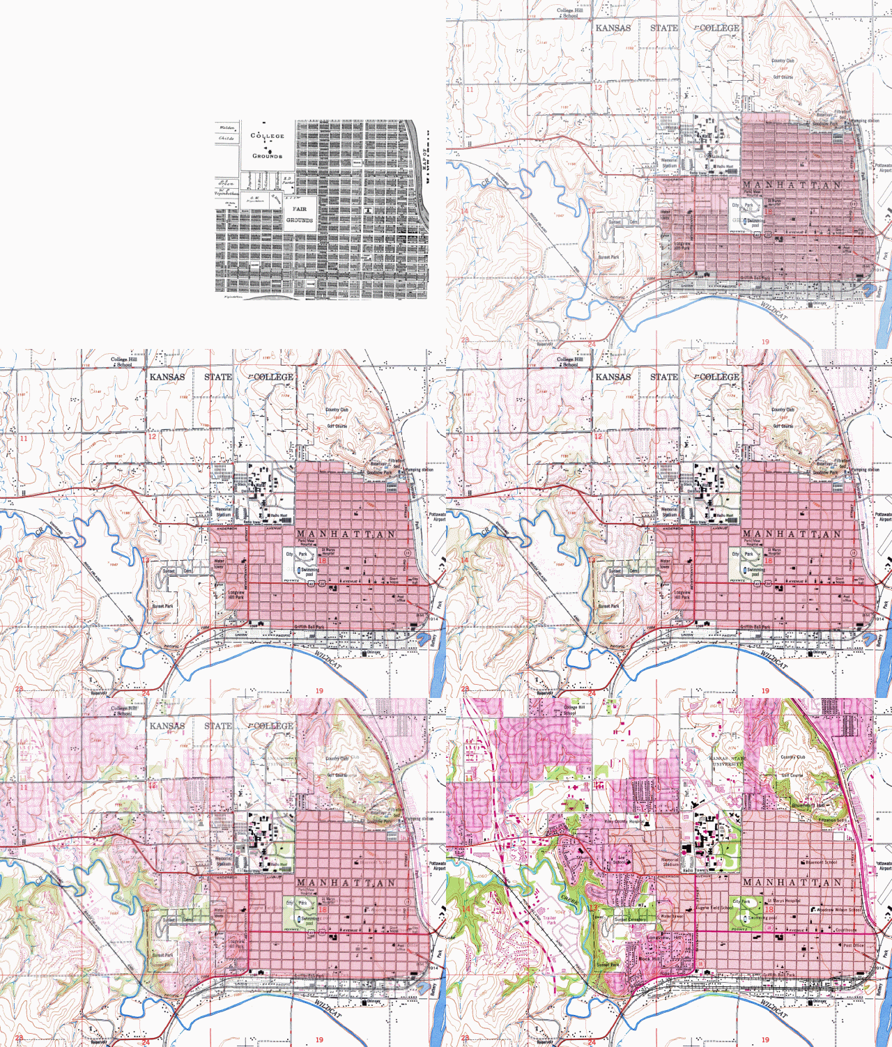
Manhattan fails this test. The original townsite plan paid NO attention to geography or terrain. It would have been nicely extensible in a flat riverless spot, but failed in the actual situation. Rivers on two sides, bluffs on the other two sides. The most noble and elegant parts of the original plan, the market squares, failed to extend at all. They were never actually built.
Here's a blinkyGIF that attempts to illustrate the failure to extend. Starts with the original townsite as of 1885. Note that the meandering rivers had already spoiled the E and S sides, and the steep bluffs were about to mess up the N and W. The GIF gradually fades into 1950 then 1965, showing how the bluffs required a more curvy and twisty street pattern. Entirely separate from the original grid. Strictly modular.
 = = = = =
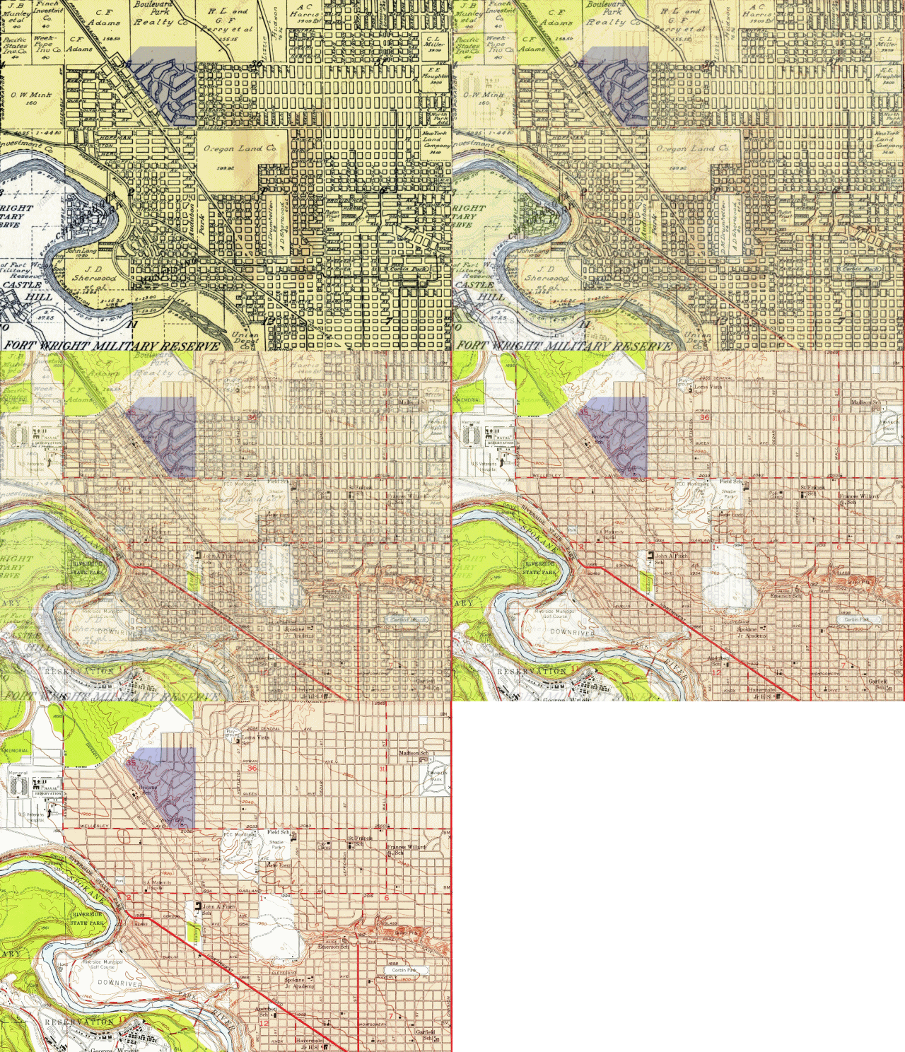
Spokane, by contrast, is highly extensible. I've used only the NW quarter, partly because I know it best and partly because the whole city is too big for clear mapping at blog-size. Starts with 1912, fades into 1960 or so. Note how newer additions extend (or extrude?) smoothly from existing patterns. Also note the area I've shaded purply-gray. This is a steep hillside, which was platted with appropriate curves in 1912 when curves were NOT the normal way to plat a city. Didn't need any change when it was actually built much later.
 Why was Spokane set up appropriately from the start? Not any grand vision for damn sure. No Brasilia or DC. More like a lack of grand vision. Do what works. Maybe because the railroads were here at the start, which forced platters to pay attention to terrain.
Non-humble artistic note: Both of these blinkies came out a lot better than I hoped! They actually illustrate what I wanted them to illustrate.
Humble artistic note: Thanks to excellent old cartographers. I expect the USGS maps to be good; they were made with aerial photos and a large surveying staff. But I didn't expect the 1885 and 1912 maps to line up so perfectly with the USGS. Those early mapmakers didn't have airplanes and big budgets.
 = = = = =
Spokane, by contrast, is highly extensible. I've used only the NW quarter, partly because I know it best and partly because the whole city is too big for clear mapping at blog-size. Starts with 1912, fades into 1960 or so. Note how newer additions extend (or extrude?) smoothly from existing patterns. Also note the area I've shaded purply-gray. This is a steep hillside, which was platted with appropriate curves in 1912 when curves were NOT the normal way to plat a city. Didn't need any change when it was actually built much later.
 Why was Spokane set up appropriately from the start? Not any grand vision for damn sure. No Brasilia or DC. More like a lack of grand vision. Do what works. Maybe because the railroads were here at the start, which forced platters to pay attention to terrain.
Non-humble artistic note: Both of these blinkies came out a lot better than I hoped! They actually illustrate what I wanted them to illustrate.
Humble artistic note: Thanks to excellent old cartographers. I expect the USGS maps to be good; they were made with aerial photos and a large surveying staff. But I didn't expect the 1885 and 1912 maps to line up so perfectly with the USGS. Those early mapmakers didn't have airplanes and big budgets.
Labels: Grand Blueprint, Heimatkunde, infill
