
Monday, October 01, 2012
Market squares
When Manhattan was first laid out in the 1860's, its founders were typically utopian, and wanted to make the city an Ideal Commercial Emporium. They included one feature that has always fascinated me. Since I'm all into decentralizing and localizing lately, maybe it's time to look closely at this feature.
I've annotated a 1940 map (from the 1940 Census website) that shows the original townsite plat clearly.
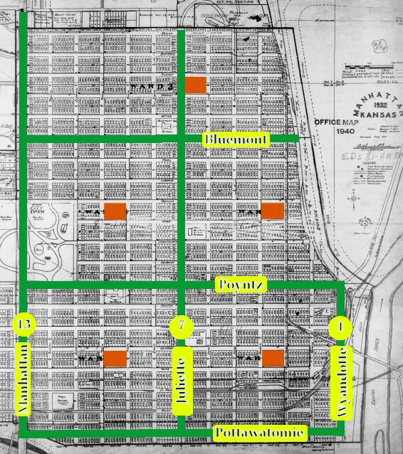 First note the Avenues, in green. They are 1/2 mile apart and they bound 6 by 6 sections containing plain old Streets. The north-south Avenues should be 1st, 7th and 13th, but they're named Wyandotte, Juliette and Manhattan Avenues. I'm guessing this was partly a sop to superstition, avoiding the numerals 7 and 13.
Real geography messed up the theoretical grid almost immediately. Wyandotte turned out to be in the river part of the time, so it never got used as a street; and ditto for Pottawatomie. The original grid extended westward to 19th (Delaware) but just barely; the bluff and the college stopped most of the grid well before that point, and curvy subdivisions continued northward and westward later.
= = = = =
I'm focusing here on the Market Squares. I've blobbed them in red on the above map. Each section was meant to have a Market Square near its center, so people could reach it easily. You'd never be more than 4 blocks from the nearest Square, which is easy walking even by modern standards. [Irrelevant sidenote: the Avenues and Market Squares form a scaled-down replica of the Jefferson township-range system that dominated Kansas. Each township enclosed 6x6 sections, and each township had a School Section near its center. Fractal!]
First note the Avenues, in green. They are 1/2 mile apart and they bound 6 by 6 sections containing plain old Streets. The north-south Avenues should be 1st, 7th and 13th, but they're named Wyandotte, Juliette and Manhattan Avenues. I'm guessing this was partly a sop to superstition, avoiding the numerals 7 and 13.
Real geography messed up the theoretical grid almost immediately. Wyandotte turned out to be in the river part of the time, so it never got used as a street; and ditto for Pottawatomie. The original grid extended westward to 19th (Delaware) but just barely; the bluff and the college stopped most of the grid well before that point, and curvy subdivisions continued northward and westward later.
= = = = =
I'm focusing here on the Market Squares. I've blobbed them in red on the above map. Each section was meant to have a Market Square near its center, so people could reach it easily. You'd never be more than 4 blocks from the nearest Square, which is easy walking even by modern standards. [Irrelevant sidenote: the Avenues and Market Squares form a scaled-down replica of the Jefferson township-range system that dominated Kansas. Each township enclosed 6x6 sections, and each township had a School Section near its center. Fractal!]
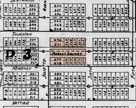 Closeup of one Market Square block, with surrounding normal blocks for context. Note the short lots around the square for business buildings facing inward; a central public agora or souk, and a pathway around the souk. You can feel the hustle and bustle, can't you? Vendors parking their carts or tables in the souk and hawking their wares; customers walking around the perimeter, looking, smelling, pinching, buying.
 Unfortunately the Squares were never implemented. Residential development took over from the utopian vision, and those blocks were 'normalized', first by vacation and easements, later by redrawing the plat.

First note the Avenues, in green. They are 1/2 mile apart and they bound 6 by 6 sections containing plain old Streets. The north-south Avenues should be 1st, 7th and 13th, but they're named Wyandotte, Juliette and Manhattan Avenues. I'm guessing this was partly a sop to superstition, avoiding the numerals 7 and 13.
Real geography messed up the theoretical grid almost immediately. Wyandotte turned out to be in the river part of the time, so it never got used as a street; and ditto for Pottawatomie. The original grid extended westward to 19th (Delaware) but just barely; the bluff and the college stopped most of the grid well before that point, and curvy subdivisions continued northward and westward later.
= = = = =
I'm focusing here on the Market Squares. I've blobbed them in red on the above map. Each section was meant to have a Market Square near its center, so people could reach it easily. You'd never be more than 4 blocks from the nearest Square, which is easy walking even by modern standards. [Irrelevant sidenote: the Avenues and Market Squares form a scaled-down replica of the Jefferson township-range system that dominated Kansas. Each township enclosed 6x6 sections, and each township had a School Section near its center. Fractal!]
Closeup of one Market Square block, with surrounding normal blocks for context. Note the short lots around the square for business buildings facing inward; a central public agora or souk, and a pathway around the souk. You can feel the hustle and bustle, can't you? Vendors parking their carts or tables in the souk and hawking their wares; customers walking around the perimeter, looking, smelling, pinching, buying.
Unfortunately the Squares were never implemented. Residential development took over from the utopian vision, and those blocks were 'normalized', first by vacation and easements, later by redrawing the plat.Labels: Heimatkunde
¶ 5:48 PM