Wednesday, February 03, 2016
Ponds again
Spokane's idiot misgovernment has succumbed to blackmail by the EPA Terrorist Army, and is building a number of Miasmal Swamps. Three of them appeared last month in my neighborhood. They occupy the middle section of the boulevard, which had been an unused strip of land with a few trees. Each pit has inflow pipes from the storm sewers on all sides.
EPA Terrorist Army requires these multi-million-dollar monstrosities to prevent .000000000000001% of horrible PCB from entering the Holy River and embarrassing one or two Holy Fish.
When I saw the Pits Of Despair my initial reaction was horror and outrage. These pits are 6 feet deep, 60 feet wide, and 400 feet long. BIG pits. They are right next to the pavement with no guardrail. Kids walk along both sides of the boulevard on their way to school, and just one slip on ice, or one push in a playfight, will drop a kid into the pit. When the pit is relatively dry this will only be messy, but when it's full after a rain, it could easily mean a drowning.
Well.
When I was a kid, what did I think of swamps and pits? Was I afraid of them? Did I see them as horrible dangers?
No. I LOVED swamps and creeks and pits. In fact I can remember an earlier episode of anger and outrage when a city ELIMINATED a swamp.
In '56 my parents moved into a new subdivision which was gradually invading a former farm. The farm had a little pond formed by a little dam, which led to an unnamed creek. The streets had been hastily built in the rush to provide new housing after the '51 flood, so this little dam and creek were still partly exposed.
BlinkyGIF time. Using USGS topo maps from 1950 and 1970, I alternate the untouched landscape and the streets of the addition.
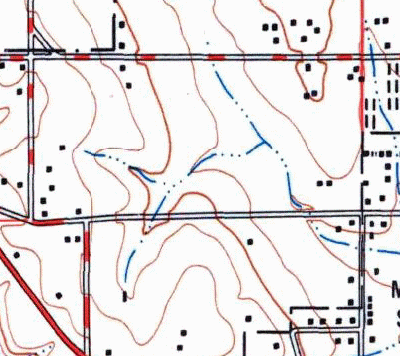 In the middle of each era, I flash the letters G and P. G is the Goodnow House for reference, and P is where the little pond and dam were. The old version of the map shows the outflow creek but not the pond. The house to the left of P was the farmhouse. Mr Anderson, the old farmer, still kept chickens but no longer planted crops. I expect he was enjoying better profits and less labor by planting subdivisions.
The remaining piece of creek was about 8 feet below the streets, in a pit. Admittedly it was a much more interesting pit than these new ones; it had pokeberry bushes, Bodock trees left over from CCC windbreaks, and critters in the creek. I hugely enjoyed climbing down from the street into this shady little haven where I could eat the pokeberries and watch snails and clams in the creek.
A couple years later, as the contractor started to build another row of houses, the pond and dam and creek were filled in. All level with the street. No more creek, no more Osage Oranges, no more snails.
I was pissed. I was a 9-year-old curmudgeon roaring against the evils of Progress. Now I'm a 66-year-old curmudgeon roaring against the evils of Progress.
How to settle this argument between 1959 Me and 2016 Me? Yesterday's writing about ponds and dams settled it. 1959 is right. Though the city's purpose is infinitely evil, the result is a good thing. More storage, more filtering, and more places for kids to explore. I could handle the 'hazard' when I was a kid; no reason to think that modern explorers are any different.
= = = = =
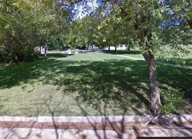
Sidenote: Googlestreet shows the fill over my former haven. Surprisingly, nobody ever built a house in that spot. Makes sense, I guess; zoning boards frown on building over deep fill.
In the middle of each era, I flash the letters G and P. G is the Goodnow House for reference, and P is where the little pond and dam were. The old version of the map shows the outflow creek but not the pond. The house to the left of P was the farmhouse. Mr Anderson, the old farmer, still kept chickens but no longer planted crops. I expect he was enjoying better profits and less labor by planting subdivisions.
The remaining piece of creek was about 8 feet below the streets, in a pit. Admittedly it was a much more interesting pit than these new ones; it had pokeberry bushes, Bodock trees left over from CCC windbreaks, and critters in the creek. I hugely enjoyed climbing down from the street into this shady little haven where I could eat the pokeberries and watch snails and clams in the creek.
A couple years later, as the contractor started to build another row of houses, the pond and dam and creek were filled in. All level with the street. No more creek, no more Osage Oranges, no more snails.
I was pissed. I was a 9-year-old curmudgeon roaring against the evils of Progress. Now I'm a 66-year-old curmudgeon roaring against the evils of Progress.
How to settle this argument between 1959 Me and 2016 Me? Yesterday's writing about ponds and dams settled it. 1959 is right. Though the city's purpose is infinitely evil, the result is a good thing. More storage, more filtering, and more places for kids to explore. I could handle the 'hazard' when I was a kid; no reason to think that modern explorers are any different.
= = = = =
Sidenote: Googlestreet shows the fill over my former haven. Surprisingly, nobody ever built a house in that spot. Makes sense, I guess; zoning boards frown on building over deep fill.
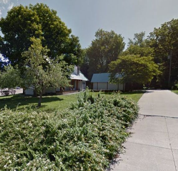
 Another surprise: Mr Anderson's farmhouse is still there. Modernized a bit, but basically the same house.


In the middle of each era, I flash the letters G and P. G is the Goodnow House for reference, and P is where the little pond and dam were. The old version of the map shows the outflow creek but not the pond. The house to the left of P was the farmhouse. Mr Anderson, the old farmer, still kept chickens but no longer planted crops. I expect he was enjoying better profits and less labor by planting subdivisions.
The remaining piece of creek was about 8 feet below the streets, in a pit. Admittedly it was a much more interesting pit than these new ones; it had pokeberry bushes, Bodock trees left over from CCC windbreaks, and critters in the creek. I hugely enjoyed climbing down from the street into this shady little haven where I could eat the pokeberries and watch snails and clams in the creek.
A couple years later, as the contractor started to build another row of houses, the pond and dam and creek were filled in. All level with the street. No more creek, no more Osage Oranges, no more snails.
I was pissed. I was a 9-year-old curmudgeon roaring against the evils of Progress. Now I'm a 66-year-old curmudgeon roaring against the evils of Progress.
How to settle this argument between 1959 Me and 2016 Me? Yesterday's writing about ponds and dams settled it. 1959 is right. Though the city's purpose is infinitely evil, the result is a good thing. More storage, more filtering, and more places for kids to explore. I could handle the 'hazard' when I was a kid; no reason to think that modern explorers are any different.
= = = = =
Sidenote: Googlestreet shows the fill over my former haven. Surprisingly, nobody ever built a house in that spot. Makes sense, I guess; zoning boards frown on building over deep fill.
Another surprise: Mr Anderson's farmhouse is still there. Modernized a bit, but basically the same house.
Labels: TMI
¶ 1:38 AM