Monday, January 18, 2016
The Great Interstate Canal
The Kansas Historical Society has a wonderful website similar to the Library of Congress resource.
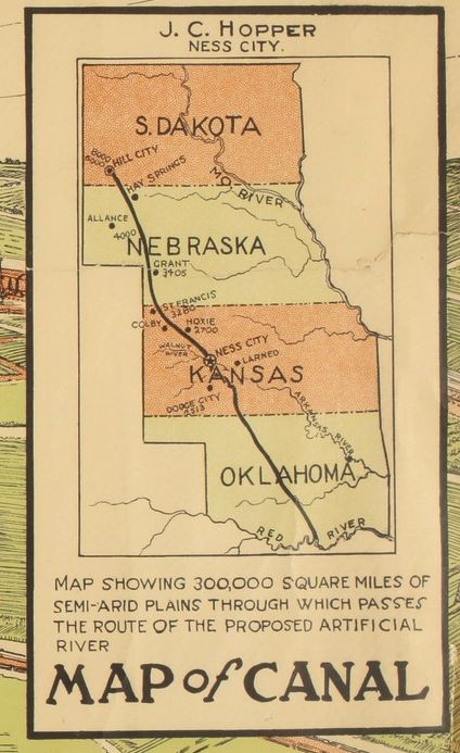
As I was browsing through maps, bumped into this splendid piece of belated utopianism. It's a 1914 proposal for a canal running more or less along the Dry Line from Canada to Galveston. (Not too far from my recent idea for a giant railroad to replace barge traffic.)
The route:
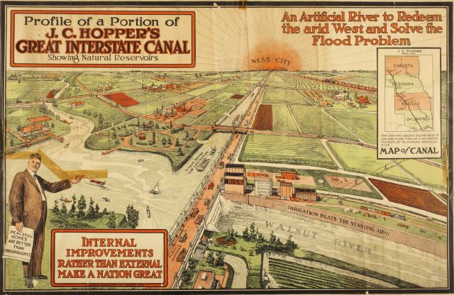
 Proposed by Mr JC Hopper of Ness City, which is pretty much self-explanatory....
 On the horizon, glowing like the rising sun, is NESS CITY!!!!! CENTER OF THE KNOWN UNIVERSE! ALL ROADS LEAD TO NESS!!!
And there's old JC, looking portly and prosperous despite the Scotch Tape over his head.
In his hand is a scroll:
Peaceful homes are better than dreadnaughts.
Below him:
Internal improvements rather than external make a nation great.
Painted on the side of the canal:
Irrigation beats the standing army.
All a little clunky, but all ABSOLUTELY CORRECT.
We DESPERATELY need to relearn and reapply all three.
Well, what happened to the Great Interstate Canal? Nothing. This map was its only product. Hopper tried to interest the gov't, with no results. BUT: Twenty years later, when the Corps of Engineers started its major dam-building, it followed the same basic principle. Hold back water behind the Dry Line, to smooth out the irregular rainy periods and provide irrigation.
Bigger map here.
Apologetic sidenote: I shouldn't be snotty toward Ness City. I've been there. It's a pleasant place, and seems to be holding up better than most Plains towns.
 Proposed by Mr JC Hopper of Ness City, which is pretty much self-explanatory....
 On the horizon, glowing like the rising sun, is NESS CITY!!!!! CENTER OF THE KNOWN UNIVERSE! ALL ROADS LEAD TO NESS!!!
And there's old JC, looking portly and prosperous despite the Scotch Tape over his head.
In his hand is a scroll:
Peaceful homes are better than dreadnaughts.
Below him:
Internal improvements rather than external make a nation great.
Painted on the side of the canal:
Irrigation beats the standing army.
All a little clunky, but all ABSOLUTELY CORRECT.
We DESPERATELY need to relearn and reapply all three.
Well, what happened to the Great Interstate Canal? Nothing. This map was its only product. Hopper tried to interest the gov't, with no results. BUT: Twenty years later, when the Corps of Engineers started its major dam-building, it followed the same basic principle. Hold back water behind the Dry Line, to smooth out the irregular rainy periods and provide irrigation.
Bigger map here.
Apologetic sidenote: I shouldn't be snotty toward Ness City. I've been there. It's a pleasant place, and seems to be holding up better than most Plains towns.
Labels: Alternate universe
