Sunday, August 23, 2015
Why is Canada less fiery?
Using an interactive map found here.
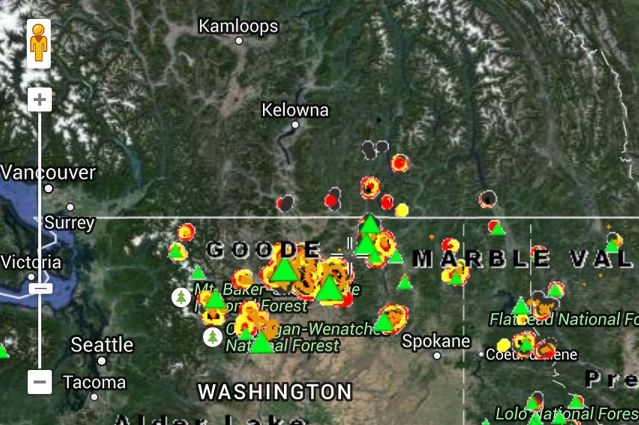
Screencap from a large view:
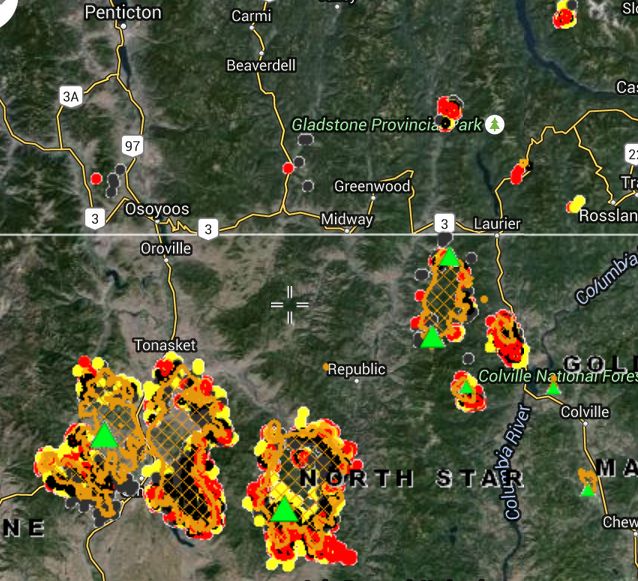
 Screencap from closeup:
 Notice something? Fires start in Canada but don't explode. One US fire almost hits the border but doesn't cross.
The forest is the same. When you scan any satellite view, you can see the same terrain, same types of trees, apparently the same general density. There is no fence or road on the border in these forests. If the map didn't add the line, you couldn't tell where the border is. (This isn't generally true at borders. In farmland or urban areas, you can ALMOST ALWAYS distinguish states and countries without the added line. Street patterns and farming methods are distinctive.)
Canada and US are treating their forests differently. I don't know what the difference is. More logging? Quicker warning of fires? More watchers? Less bureaucracy? Less idiocy about "endangered species"?
SOMETHING is different, and the correlation to GOVERNMENT is BLAZINGLY obvious.
We're doing everything wrong. Canada isn't.
 Screencap from closeup:
 Notice something? Fires start in Canada but don't explode. One US fire almost hits the border but doesn't cross.
The forest is the same. When you scan any satellite view, you can see the same terrain, same types of trees, apparently the same general density. There is no fence or road on the border in these forests. If the map didn't add the line, you couldn't tell where the border is. (This isn't generally true at borders. In farmland or urban areas, you can ALMOST ALWAYS distinguish states and countries without the added line. Street patterns and farming methods are distinctive.)
Canada and US are treating their forests differently. I don't know what the difference is. More logging? Quicker warning of fires? More watchers? Less bureaucracy? Less idiocy about "endangered species"?
SOMETHING is different, and the correlation to GOVERNMENT is BLAZINGLY obvious.
We're doing everything wrong. Canada isn't.
Notice something? Fires start in Canada but don't explode. One US fire almost hits the border but doesn't cross.
The forest is the same. When you scan any satellite view, you can see the same terrain, same types of trees, apparently the same general density. There is no fence or road on the border in these forests. If the map didn't add the line, you couldn't tell where the border is. (This isn't generally true at borders. In farmland or urban areas, you can ALMOST ALWAYS distinguish states and countries without the added line. Street patterns and farming methods are distinctive.)
Canada and US are treating their forests differently. I don't know what the difference is. More logging? Quicker warning of fires? More watchers? Less bureaucracy? Less idiocy about "endangered species"?
SOMETHING is different, and the correlation to GOVERNMENT is BLAZINGLY obvious.
We're doing everything wrong. Canada isn't.Labels: STRONG!
