Tuesday, August 12, 2014
Blip
Meteorologists often talk about a warm surge getting pushed ahead of a cold front. I'd never noticed the phenomenon before.
Yesterday the morning radio hosts were reading the area temperatures, which are normally boring. Not much difference, not worth reading separately. Most were around 63.... but Pullman showed 80. The host said "That can't be right! Must be a bad sensor or a computer glitch or something." (Pullman is typically a few degrees below Spokane. Higher altitude, no Urban Heat Island.)
I looked at the NWS site, and sure enough it was right:
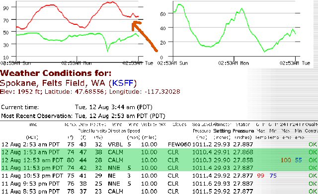
 Now this morning the same little warm surge reached Spokane:
 Remains to be seen when the cold front will arrive. Let's hope it isn't as dramatic as the last two.
[Tech note to self: Looks like the scaling on my PaintShop is set wrong somehow. Lately it's been pixelating like this. Probably need to return it to default.]
 Now this morning the same little warm surge reached Spokane:
 Remains to be seen when the cold front will arrive. Let's hope it isn't as dramatic as the last two.
[Tech note to self: Looks like the scaling on my PaintShop is set wrong somehow. Lately it's been pixelating like this. Probably need to return it to default.]
